My first iceberg: Nascent (south)
The first flight I was scheduled to go on was to the Nascent Iceberg. The word “Nascent” means “about to be born”. So, if you can guess by the name, it is actually not yet an iceberg. The Ross Ice Shelf calves off massive icebergs every 50 years or so. The Nascent Iceberg will be the next big iceberg. Right now, it is a rift zone- a place where the iceberg is slowly separating from the ice shelf.
We already had a station on the north side of the rift (north is the side becoming an iceberg). At that station we have a seismometer, weather station, and even a camera that looks into the giant rift zone! So our group was actually going to the south side of the rift. What we want to do is put GPS on both sides (north and south) so that we can measure the rate that the rift zone is spreading. We also believe the rifting is caused by the tides, so we want to watch and see whether or not the rifting is continuous, or if it corresponds with tides.
So, for my trip, I was going to the south side of the rift to put the GPS equipment up in two different locations. Later, a team would go to the north side and put up another GPS.
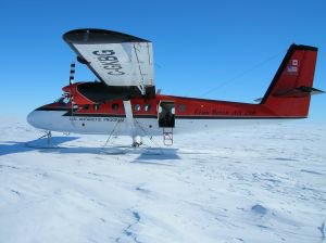
Here is a picture of the plane we flew in, called a “Twin Otter” and a picture of three of us inside (myself, Ronald, and Doug). I had a cold, so all of the pressure made my head hurt! It felt like my eyeballs were popping out, but the flight was still beautiful.


Instead of landing on wheels, the Twin Otter has four skis. Below is a close-up of one of them. The pilot would bring the plane down very gently, ski over the snow, and pull back up. They would then fly back around, looking at their ski tracks. If they looked solid, they know that there are no crevasses, and that it is safe to land there again.

For our trip to Nascent it took many attempts before landing- not because there were crevasses, but because the snow was so hard. They couldn't find their tracks to land in again! Once we finally landed, I tried to make a snow angel, but the snow was too hard! Here is a nice picture of the rift area.

Here is a picture of Jonathan on the plane. You can see that he is wearing a headphone so he can talk to the pilot, because the plane is too noisy to talk normally. The flight to Nascent was about 1.5 hours.

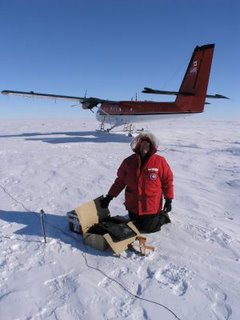
When we did land, we got to set up our equipment. Here is a picture of me setting up some GPS equipment. You can see the white antenna, the yellow tripod, and the blue solar panels. In the wooden box is a battery.

There were four people to set up the equipment, and two pilots. Often the pilots will volunteer to help (we have a lot of shoveling and setting up to do) but that can be dangerous- we wouldn’t want our pilot to be injured! We need someone to fly us home!
We also tested some radar equipment. The radar is used to measure how thick the ice is. Here is a picture of Doug setting up the equipment.

A week later, another group went to the north side of the rift. They also put up GPS equipment, and we’d already had a seismometer that they had to take back home. They also had to remove a camera that wasn’t working. The camera took pictures of the rift zone (people had to wear ropes to go near the camera, because we wouldn’t want anyone to fall into the rift!). This is a great picture. It was taken by Jonathan from the plane. You can see the rift, the camera, and the plane! (Look closely for the camera- it is on a tripod right by the plane shadow).

When we were at Nascent, Ronald (in middle of picture) wanted to collect snow. He and his wife are getting married on Friday (Nov 11th) and they both were in Antarctica together. So he thought it would be nice if everyone drank water from Antarctica. So here we are, right before leaving, collecting snow.

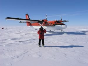
It was very beautiful standing out there, where so few people have been. The weather was wonderful, although I am definitely bundled up (last year they got trapped there for over four days due to the weather!). There are lots of things to see at McMurdo, but on the ice shelf it was flat in every direction you looked, as you can see in this picture of me.

We already had a station on the north side of the rift (north is the side becoming an iceberg). At that station we have a seismometer, weather station, and even a camera that looks into the giant rift zone! So our group was actually going to the south side of the rift. What we want to do is put GPS on both sides (north and south) so that we can measure the rate that the rift zone is spreading. We also believe the rifting is caused by the tides, so we want to watch and see whether or not the rifting is continuous, or if it corresponds with tides.
So, for my trip, I was going to the south side of the rift to put the GPS equipment up in two different locations. Later, a team would go to the north side and put up another GPS.
Here is a picture of the plane we flew in, called a “Twin Otter” and a picture of three of us inside (myself, Ronald, and Doug). I had a cold, so all of the pressure made my head hurt! It felt like my eyeballs were popping out, but the flight was still beautiful.


Instead of landing on wheels, the Twin Otter has four skis. Below is a close-up of one of them. The pilot would bring the plane down very gently, ski over the snow, and pull back up. They would then fly back around, looking at their ski tracks. If they looked solid, they know that there are no crevasses, and that it is safe to land there again.

For our trip to Nascent it took many attempts before landing- not because there were crevasses, but because the snow was so hard. They couldn't find their tracks to land in again! Once we finally landed, I tried to make a snow angel, but the snow was too hard! Here is a nice picture of the rift area.

Here is a picture of Jonathan on the plane. You can see that he is wearing a headphone so he can talk to the pilot, because the plane is too noisy to talk normally. The flight to Nascent was about 1.5 hours.

When we did land, we got to set up our equipment. Here is a picture of me setting up some GPS equipment. You can see the white antenna, the yellow tripod, and the blue solar panels. In the wooden box is a battery.

There were four people to set up the equipment, and two pilots. Often the pilots will volunteer to help (we have a lot of shoveling and setting up to do) but that can be dangerous- we wouldn’t want our pilot to be injured! We need someone to fly us home!
We also tested some radar equipment. The radar is used to measure how thick the ice is. Here is a picture of Doug setting up the equipment.

A week later, another group went to the north side of the rift. They also put up GPS equipment, and we’d already had a seismometer that they had to take back home. They also had to remove a camera that wasn’t working. The camera took pictures of the rift zone (people had to wear ropes to go near the camera, because we wouldn’t want anyone to fall into the rift!). This is a great picture. It was taken by Jonathan from the plane. You can see the rift, the camera, and the plane! (Look closely for the camera- it is on a tripod right by the plane shadow).

When we were at Nascent, Ronald (in middle of picture) wanted to collect snow. He and his wife are getting married on Friday (Nov 11th) and they both were in Antarctica together. So he thought it would be nice if everyone drank water from Antarctica. So here we are, right before leaving, collecting snow.

It was very beautiful standing out there, where so few people have been. The weather was wonderful, although I am definitely bundled up (last year they got trapped there for over four days due to the weather!). There are lots of things to see at McMurdo, but on the ice shelf it was flat in every direction you looked, as you can see in this picture of me.


